Masking - APCC MME Tutorial
The masking feature provides geographic information-based masking data for precise extraction of climate data.
It offers users area boundary information that allows them to easily access visualization services based on desired climate data and detailed data extraction services utilizing geographic information.
Additionally, the masking feature utilizes the Python library PyWPS, which enables the implementation of OGC WPS (Open Geospatial Consortium Web Processing Service) standard services, to provide the necessary technology for processing climate data.
This service generates and provides mask data using ISO-3166-1 country codes without the need for country boundary data.
In the masking feature, four Masking Operators are provided to extract geographical information, and their algorithms are as follows:
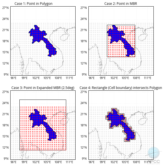
Determines if a point is inside a given polygon. It checks whether the point is within the boundaries and interior of the polygon.
Determines if a point is within the given MBR. MBR is the minimum-sized rectangle that surrounds the country boundary.
Determines if a point is within the expanded area of the MBR (based on the Distance value). It extends the MBR of the country boundary to create a rectangular area for determination.
Determines if a rectangle (cell boundary) intersects with a polygon. It checks for overlap or intersection between the cell boundary and the polygon.
Masking APCC MME Tutorial
Notice : MME data is updated around the 20th of every month and may change depending on operational situation.
;)
;)
;)